- Distributed data management
-
The core partner data centres that are integrated in NorDataNet are listed in https://www.nordatanet.no/en/node/69. In addition to this NorDataNet harvests information on relevant datasets from a number of other data centres. The data centre responsible for the data presented is usually (but not always) listed in the discovery metadata. In essence NorDataNet is an aggregating service that combines information from a number of existing data centres.
- Citation of data and service
-
If you use data retrieved through this portal, please acknowledge our funding source:
- Research Council of Norway, project number 245967/F50, Norwegian Scientific Data Network.
Always remember to cite data when used!
Citation information for individual datasets is often provided in the metadata. However, not all datasets have this information embedded in the discovery metadata. On a general basis a citation of a dataset include the same components as any other citation:
- author, title,
- year of publication,
- publisher (for data this is often the archive where it is housed),
- edition or version,
- access information (a URL or persistent identifier, e.g. DOI if provided)
All partner repositories of NorDataNet support Digital Object Identifiers (DOI), but not all datasets are minted. Whether or not minted depends often on source of the data (e.g. operational data are often yet not minted). However, all data centres support persistent identifiers according to local systems. The information required to properly cite a dataset is normally provided in the discovery metadata the datasets.
- Brief user guide
-
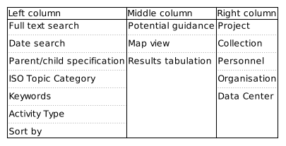
Outline of the data portal search interface. The Data Access Portal has information in 3 columns. An outline of the content in these columns is provided above. When first entering the search interface, all potential datasets are listed. Datasets are indicated in the map and results tabulation elements which are located in the middle column. The order of results can be modified using the "Sort by" option in the left column. On top of this column is normally relevant guidance information to user presented as collapsible elements.
If the user want to refine the search, this can be done by constraining the bounding box search. This is done in the map - the listing of datasets is automatically updated. Date constraints can be added in the left column. For these to take effect, the user has to push the button marked search. In the left column it is also possible to specific text elements to search for in the datasets. Again pushing the button marked "Search" is necessary for these to take action. Complex search patterns can be constructed using logical operators identified in the drop down menu with and phrases embedded in quotation marks. Prefixing a phrase with '-' negates the phrase (i.e. should not occur in the results). Searches are case insensitive.
Other elements indicated in the left and right columns are facet searches, i.e. these are keywords that are found in the datasets and all datasets that contain these specific keywords in the appropriate metadata elements are listed together. Further refinement can be done using full text, date or bounding box constraints. Individuals, organisations and data centres involved in generating or curating the datasets are listed in the facets in the right column. The combination of search fields (including facets) is based on a logical "AND" combination of the fields, i.e. all conditions are fulfilled for the results provided.
Visualize timeseries

CryoClim (CryoClim)
Institutions: Norwegian Water Resources and Energy Directorate (NVE)Show more...
Abstract:
The climate change indicator products of glaciers in mainland Norway include surface mass balance and length change (from NVE’s field observations) and area changes (from satellite imagery and topographical maps) for a selection of glaciers. Glacier surface mass balance and glacier length change are obtained directly from NVE’s databases. https://glacier.nve.no/Glacier/viewer/CI/en/ccAccess: Open-
CryoClim (CryoClim)
Institutions: Norwegian Water Resources and Energy Directorate (NVE)Show more...
Abstract:
Glacier Periodic photos (GPP) from Norwegian glaciers. The photo series illustrate how the extent of a selection of Norwegian glaciers have changed. The pictures are not taken from the same position each year. The earliest photos are from the 1860s. The majority of the pictures are from the last 20 years. The number of photos per glacier varies. The source of the data is NVEs photo archive, with contributions from NVE collaborators. https://glacier.nve.no/Glacier/viewer/gpp/en/cc/Access: Open -
CryoClim (CryoClim)
Institutions: Norwegian Water Resources and Energy Directorate (NVE)Show more...
Abstract:
Registered incidents of Glacier Lake Outburst floods (GLOFs) in mainland Norway. https://glacier.nve.no/Glacier/viewer/GLOF/en/cc/Access: Open -
CryoClim
Institutions: Norwegian Water Resources and Energy Directorate (NVE), Norwegian Water Resources and Energy Directorate (NVE), Norwegian Water Resources and Energy Directorate (NVE), Norwegian Water Resources and Energy Directorate (NVE)Show more...
Abstract:
Sentinel-2 imagery was used to map the extent of Norway’s glaciers over 2018–19. A standardized semi-automated band ratio method was used to derive glacier outlines. To optimise the results, manual edits of ice-lake interfaces, debris, snow, and parts of the glaciers situated under shadow were applied. The data set and the uncertainties are described in Andreassen et al. (2022; Journal of Glaciology).Access: Open